Thank you for supporting this site ❤️
Make a donation
Make a donation
Gear up for your next adventure:
As an Amazon Associate, this site earns from qualifying purchases at no extra cost to you.
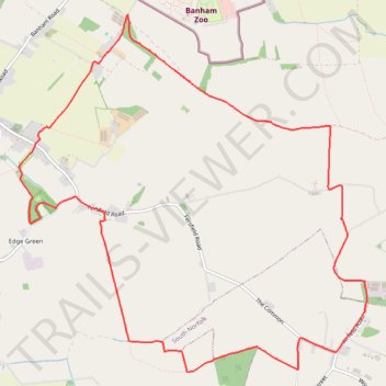
Loop walk from Kenninghall
- Distance: 7.8 mi
- Elevation gain: 59 m
- Maximum elevation: 56 m
- Elevation loss: 59 m
- Minimum elevation: 35 m
- Moving time: 2 h 39 m
- Moving speed: 2.9 mph
- Maximum speed: 7.1 mph
- Total time: 2 h 50 m
- Global speed: 2.7 mph
Interactive trail map
Thank you for supporting this site ❤️
Make a donation
Make a donation
Gear up for your next adventure:
As an Amazon Associate, this site earns from qualifying purchases at no extra cost to you.
Trail profile
- Distance: 7.8 mi
- Elevation gain: 59 m
- Maximum elevation: 56 m
- Elevation loss: 59 m
- Minimum elevation: 35 m
- Moving time: 2 h 39 m
- Moving speed: 2.9 mph
- Maximum speed: 7.1 mph
- Total time: 2 h 50 m
- Global speed: 2.7 mph
Thank you for supporting this site ❤️
Make a donation
Make a donation
Gear up for your next adventure:
As an Amazon Associate, this site earns from qualifying purchases at no extra cost to you.
About this trail
Name: Loop walk from Kenninghall trail, distance, elevation, map, profile, GPS track
Coordinates: 52.41377 1.00174 52.44342 1.04909
Topography: Breckland District topographic map, elevation, terrain
Thank you for supporting this site ❤️
Make a donation
Make a donation
Gear up for your next adventure:
As an Amazon Associate, this site earns from qualifying purchases at no extra cost to you.