Make a donation
Gear up for your next adventure:
As an Amazon Associate, this site earns from qualifying purchases at no extra cost to you.
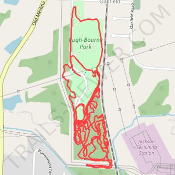
Pugh-Bourne Park Rockabilly MTB Trails
- Distance: 6.5 mi
- Elevation gain: 58 m
- Maximum elevation: 139 m
- Elevation loss: 59 m
- Minimum elevation: 121 m
- Moving time: 45 m 35 s
- Moving speed: 8.6 mph
- Maximum speed: 18.8 mph
- Total time: 48 m 9 s
- Global speed: 8.1 mph
Interactive trail map
Make a donation
Gear up for your next adventure:
As an Amazon Associate, this site earns from qualifying purchases at no extra cost to you.
Trail profile
- Distance: 6.5 mi
- Elevation gain: 58 m
- Maximum elevation: 139 m
- Elevation loss: 59 m
- Minimum elevation: 121 m
- Moving time: 45 m 35 s
- Moving speed: 8.6 mph
- Maximum speed: 18.8 mph
- Total time: 48 m 9 s
- Global speed: 8.1 mph
Make a donation
Gear up for your next adventure:
As an Amazon Associate, this site earns from qualifying purchases at no extra cost to you.
About this trail
Name: Pugh-Bourne Park Rockabilly MTB Trails trail, distance, elevation, map, profile, GPS track
End: Oakfield, Madison County, West Tennessee, Tennessee, 38362, United States (35.70802 -88.79654)
Coordinates: 35.70143 -88.79810 35.71302 -88.79375
Make a donation
Gear up for your next adventure:
As an Amazon Associate, this site earns from qualifying purchases at no extra cost to you.
Other hiking, mountain biking, running and outdoor activity trails
Click on a trail to view its statistics, map and profile.
Gmaps Pedometer Route
United States > Kentucky > Fulton County > Hickman
Distance: 312.5 mi • Elevation gain: 4,204 m • Maximum elevation: 592 m