Thank you for supporting this site ❤️
Make a donation
Make a donation
Gear up for your next adventure:
As an Amazon Associate, this site earns from qualifying purchases at no extra cost to you.
Westville Conservation Area Loop
Interactive trail map
Thank you for supporting this site ❤️
Make a donation
Make a donation
Gear up for your next adventure:
As an Amazon Associate, this site earns from qualifying purchases at no extra cost to you.
Trail profile
- Distance: 3.8 mi
- Elevation gain: 23 m
- Maximum elevation: 16 m
- Elevation loss: 23 m
- Minimum elevation: 9 m
- Moving time: 1 h 45 m
- Moving speed: 2.2 mph
- Maximum speed: 3.5 mph
- Total time: 2 h 30 s
- Global speed: 1.9 mph
Thank you for supporting this site ❤️
Make a donation
Make a donation
Gear up for your next adventure:
As an Amazon Associate, this site earns from qualifying purchases at no extra cost to you.
About this trail
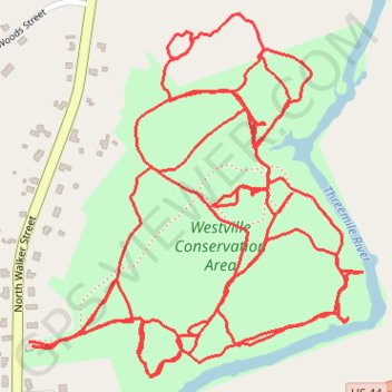
Name: Westville Conservation Area Loop trail, distance, elevation, map, profile, GPS track
Coordinates: 41.88763 -71.13542 41.89311 -71.12865
Thank you for supporting this site ❤️
Make a donation
Make a donation
Gear up for your next adventure:
As an Amazon Associate, this site earns from qualifying purchases at no extra cost to you.
Other hiking, mountain biking, running and outdoor activity trails
Click on a trail to view its statistics, map and profile.
Dedham-Providence-Dedham
United States > Massachusetts > Norfolk County > Dedham
Distance: 126.0 mi • Elevation gain: 1,811 m • Maximum elevation: 167 m