Thank you for supporting this site ❤️
Make a donation
Make a donation
Gear up for your next adventure:
As an Amazon Associate, this site earns from qualifying purchases at no extra cost to you.
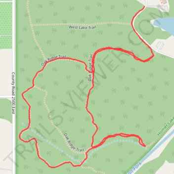
Oak Ridge Trail in Homer Lake Forest Preserve
- Distance: 1.8 mi
- Elevation gain: 19 m
- Maximum elevation: 203 m
- Elevation loss: 18 m
- Minimum elevation: 192 m
- Moving time: 48 m 7 s
- Moving speed: 2.3 mph
- Maximum speed: 3.8 mph
- Total time: 57 m 1 s
- Global speed: 1.9 mph
Interactive trail map
Thank you for supporting this site ❤️
Make a donation
Make a donation
Gear up for your next adventure:
As an Amazon Associate, this site earns from qualifying purchases at no extra cost to you.
Trail profile
- Distance: 1.8 mi
- Elevation gain: 19 m
- Maximum elevation: 203 m
- Elevation loss: 18 m
- Minimum elevation: 192 m
- Moving time: 48 m 7 s
- Moving speed: 2.3 mph
- Maximum speed: 3.8 mph
- Total time: 57 m 1 s
- Global speed: 1.9 mph
Thank you for supporting this site ❤️
Make a donation
Make a donation
Gear up for your next adventure:
As an Amazon Associate, this site earns from qualifying purchases at no extra cost to you.
About this trail
Name: Oak Ridge Trail in Homer Lake Forest Preserve trail, distance, elevation, map, profile, GPS track
Start: West Lake Trail, Champaign County, Illinois, 61849, United States (40.06138 -87.98803)
End: Oak Ridge Trail, Champaign County, Illinois, 61849, United States (40.05952 -87.98755)
Coordinates: 40.05528 -87.99421 40.06138 -87.98755
Thank you for supporting this site ❤️
Make a donation
Make a donation
Gear up for your next adventure:
As an Amazon Associate, this site earns from qualifying purchases at no extra cost to you.