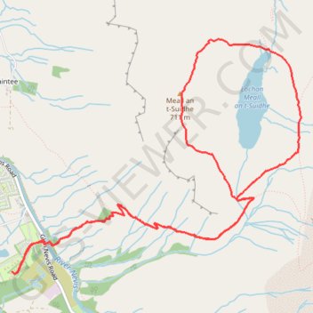
Meall an t-Suidhe and Lochan Meall an t-Suidhe Loop
Loop hike from Glen Nevis to Meall an t-Suidhe and Lochan Meall an t-Suidhe via Ben Nevis Mountain Path. #Hiking #Loop #Nature #Forest #Mountain #Lake
- Distance: 5.7 mi
- Elevation gain: 757 m
- Maximum elevation: 704 m
- Elevation loss: 757 m
- Minimum elevation: 21 m
- Moving time: 3 h 50 m
- Moving speed: 1.5 mph
- Maximum speed: 3.3 mph
- Total time: 4 h 46 m
- Global speed: 1.2 mph
Interactive trail map
Trail profile
- Distance: 5.7 mi
- Elevation gain: 757 m
- Maximum elevation: 704 m
- Elevation loss: 757 m
- Minimum elevation: 21 m
- Moving time: 3 h 50 m
- Moving speed: 1.5 mph
- Maximum speed: 3.3 mph
- Total time: 4 h 46 m
- Global speed: 1.2 mph
About this trail
Name: Meall an t-Suidhe and Lochan Meall an t-Suidhe Loop trail, distance, elevation, map, profile, GPS track
Coordinates: 56.79799 -5.07144 56.81376 -5.03595
Topography: Highland topographic map, elevation, terrain