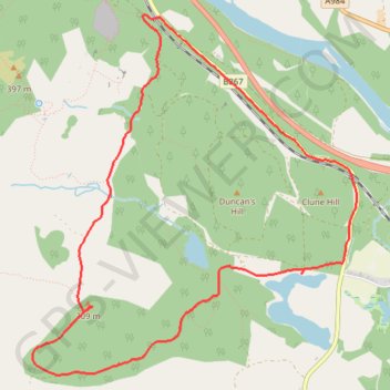
Birnam Robin's Dam Loop
Loop MTB / gravel / hike from Birnam to Robin's Dam via Stair Bridge Viewpoint and Stare Dam - Rohallion Loch. #MTB #Gravel #Hiking #Loop #Forest #Nature #Lake #Dam #River
- Distance: 4.6 mi
- Elevation gain: 246 m
- Maximum elevation: 307 m
- Elevation loss: 247 m
- Minimum elevation: 80 m
- Moving time: 58 m 44 s
- Moving speed: 4.7 mph
- Maximum speed: 20.4 mph
- Total time: 1 h 8 m
- Global speed: 4.0 mph
Interactive trail map
Trail profile
- Distance: 4.6 mi
- Elevation gain: 246 m
- Maximum elevation: 307 m
- Elevation loss: 247 m
- Minimum elevation: 80 m
- Moving time: 58 m 44 s
- Moving speed: 4.7 mph
- Maximum speed: 20.4 mph
- Total time: 1 h 8 m
- Global speed: 4.0 mph
About this trail
Name: Birnam Robin's Dam Loop trail, distance, elevation, map, profile, GPS track
Start: B867, Dunkeld, Perth and Kinross, Scotland, PH8 0DW, United Kingdom (56.54624 -3.56081)
End: B867, Dunkeld, Perth and Kinross, Scotland, PH8 0DW, United Kingdom (56.54629 -3.56102)
Coordinates: 56.52634 -3.57382 56.54651 -3.54095
Topography: Perth and Kinross topographic map, elevation, terrain
Other hiking, mountain biking, running and outdoor activity trails
Click on a trail to view its statistics, map and profile.
EMTB Gravel: Murthly - Birnam - Loop
United Kingdom > Scotland > Perth and Kinross > Newlands
Around Dunkeld, Perthshire Scotland
Distance: 28.8 mi • Elevation gain: 869 m • Maximum elevation: 305 m
Mountain Bike loop ride around Murthly, Perthshire Scotland
United Kingdom > Scotland > Perth and Kinross > Murthly > Gellyburn
UK, Perthshire, Dunkeld, Murthly
Distance: 11.2 mi • Elevation gain: 298 m • Maximum elevation: 178 m