Thank you for supporting this site ❤️
Make a donation
Make a donation
Gear up for your next adventure:
As an Amazon Associate, this site earns from qualifying purchases at no extra cost to you.
McCallum Pond
Interactive trail map
Thank you for supporting this site ❤️
Make a donation
Make a donation
Gear up for your next adventure:
As an Amazon Associate, this site earns from qualifying purchases at no extra cost to you.
Trail profile
- Distance: 1.4 mi
- Elevation gain: 58 m
- Maximum elevation: 219 m
- Elevation loss: 18 m
- Minimum elevation: 167 m
Thank you for supporting this site ❤️
Make a donation
Make a donation
Gear up for your next adventure:
As an Amazon Associate, this site earns from qualifying purchases at no extra cost to you.
About this trail
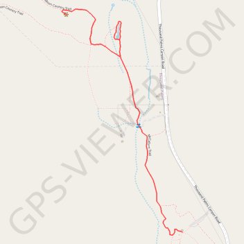
Name: McCallum Pond trail, distance, elevation, map, profile, GPS track
Start: McCallum Trail, Riverside County, California, United States (33.83749 -116.30934)
End: Moon Country Trail, Riverside County, California, United States (33.84846 -116.31635)
Coordinates: 33.83736 -116.31667 33.84876 -116.30934
Thank you for supporting this site ❤️
Make a donation
Make a donation
Gear up for your next adventure:
As an Amazon Associate, this site earns from qualifying purchases at no extra cost to you.