Thank you for supporting this site ❤️
Make a donation
Make a donation
Gear up for your next adventure:
As an Amazon Associate, this site earns from qualifying purchases at no extra cost to you.
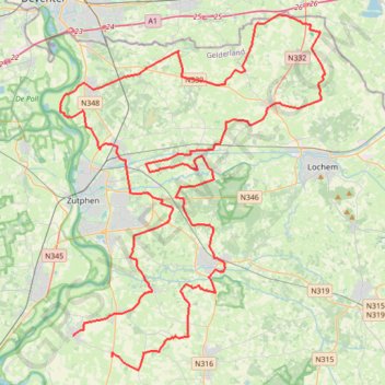
Track-brommers kieken in karke steenderen 10 aug 2024
- Distance: 63.2 mi
- Elevation gain: 141 m
- Maximum elevation: 16 m
- Elevation loss: 141 m
- Minimum elevation: 5 m
Interactive trail map
Thank you for supporting this site ❤️
Make a donation
Make a donation
Gear up for your next adventure:
As an Amazon Associate, this site earns from qualifying purchases at no extra cost to you.
Trail profile
- Distance: 63.2 mi
- Elevation gain: 141 m
- Maximum elevation: 16 m
- Elevation loss: 141 m
- Minimum elevation: 5 m
Thank you for supporting this site ❤️
Make a donation
Make a donation
Gear up for your next adventure:
As an Amazon Associate, this site earns from qualifying purchases at no extra cost to you.
About this trail
Name: Track-brommers kieken in karke steenderen 10 aug 2024 trail, distance, elevation, map, profile, GPS track
Coordinates: 52.04361 6.17402 52.24398 6.41649
Thank you for supporting this site ❤️
Make a donation
Make a donation
Gear up for your next adventure:
As an Amazon Associate, this site earns from qualifying purchases at no extra cost to you.