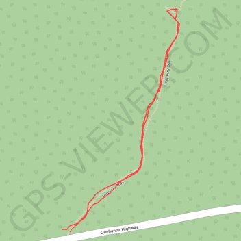
Teaberry Trail
- Distance: 0.4 mi
- Elevation gain: 23 m
- Maximum elevation: 601 m
- Elevation loss: 23 m
- Minimum elevation: 577 m
- Moving time: 8 m 43 s
- Moving speed: 2.9 mph
- Maximum speed: 4.3 mph
- Total time: 17 m 3 s
- Global speed: 1.5 mph
Interactive trail map
Trail profile
- Distance: 0.4 mi
- Elevation gain: 23 m
- Maximum elevation: 601 m
- Elevation loss: 23 m
- Minimum elevation: 577 m
- Moving time: 8 m 43 s
- Moving speed: 2.9 mph
- Maximum speed: 4.3 mph
- Total time: 17 m 3 s
- Global speed: 1.5 mph
About this trail
Name: Teaberry Trail trail, distance, elevation, map, profile, GPS track
Coordinates: 41.26355 -78.25188 41.26598 -78.25017
Other hiking, mountain biking, running and outdoor activity trails
Click on a trail to view its statistics, map and profile.
Beaver Run Loop Walk via Teaberry Trail and Quehanna East Cross Connector
United States > Pennsylvania > Elk County > Benezette Township
Distance: 5.9 mi • Elevation gain: 169 m • Maximum elevation: 625 m