Thank you for supporting this site ❤️
Make a donation
Make a donation
Gear up for your next adventure:
As an Amazon Associate, this site earns from qualifying purchases at no extra cost to you.
Derby Pond
- Distance: 0.6 mi
- Elevation gain: 9 m
- Maximum elevation: 108 m
- Elevation loss: 12 m
- Minimum elevation: 98 m
- Moving time: 15 m 17 s
- Moving speed: 2.3 mph
- Maximum speed: 3.4 mph
- Total time: 18 m 21 s
- Global speed: 1.9 mph
Interactive trail map
Thank you for supporting this site ❤️
Make a donation
Make a donation
Gear up for your next adventure:
As an Amazon Associate, this site earns from qualifying purchases at no extra cost to you.
Trail profile
- Distance: 0.6 mi
- Elevation gain: 9 m
- Maximum elevation: 108 m
- Elevation loss: 12 m
- Minimum elevation: 98 m
- Moving time: 15 m 17 s
- Moving speed: 2.3 mph
- Maximum speed: 3.4 mph
- Total time: 18 m 21 s
- Global speed: 1.9 mph
Thank you for supporting this site ❤️
Make a donation
Make a donation
Gear up for your next adventure:
As an Amazon Associate, this site earns from qualifying purchases at no extra cost to you.
About this trail
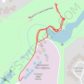
Name: Derby Pond trail, distance, elevation, map, profile, GPS track
Coordinates: 48.75179 -122.42870 48.75457 -122.42619
Thank you for supporting this site ❤️
Make a donation
Make a donation
Gear up for your next adventure:
As an Amazon Associate, this site earns from qualifying purchases at no extra cost to you.