Thank you for supporting this site ❤️
Make a donation
Make a donation
Gear up for your next adventure:
As an Amazon Associate, this site earns from qualifying purchases at no extra cost to you.
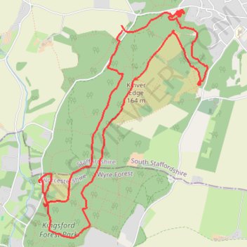
Kinver Edge Loop Walk
- Distance: 5.6 mi
- Elevation gain: 253 m
- Maximum elevation: 161 m
- Elevation loss: 248 m
- Minimum elevation: 66 m
- Moving time: 3 h 2 m
- Moving speed: 1.9 mph
- Maximum speed: 9.1 mph
- Total time: 4 h 51 m
- Global speed: 1.2 mph
Interactive trail map
Thank you for supporting this site ❤️
Make a donation
Make a donation
Gear up for your next adventure:
As an Amazon Associate, this site earns from qualifying purchases at no extra cost to you.
Trail profile
- Distance: 5.6 mi
- Elevation gain: 253 m
- Maximum elevation: 161 m
- Elevation loss: 248 m
- Minimum elevation: 66 m
- Moving time: 3 h 2 m
- Moving speed: 1.9 mph
- Maximum speed: 9.1 mph
- Total time: 4 h 51 m
- Global speed: 1.2 mph
Thank you for supporting this site ❤️
Make a donation
Make a donation
Gear up for your next adventure:
As an Amazon Associate, this site earns from qualifying purchases at no extra cost to you.
About this trail
Name: Kinver Edge Loop Walk trail, distance, elevation, map, profile, GPS track
Coordinates: 52.43195 -2.26053 52.45048 -2.23812
Topography: South Staffordshire topographic map, elevation, terrain
Thank you for supporting this site ❤️
Make a donation
Make a donation
Gear up for your next adventure:
As an Amazon Associate, this site earns from qualifying purchases at no extra cost to you.