Thank you for supporting this site ❤️
Make a donation
Make a donation
Gear up for your next adventure:
As an Amazon Associate, this site earns from qualifying purchases at no extra cost to you.
Laurel Creek Nature Centre
- Distance: 5.1 mi
- Elevation gain: 43 m
- Maximum elevation: 354 m
- Elevation loss: 43 m
- Minimum elevation: 344 m
- Moving time: 57 m 30 s
- Moving speed: 5.3 mph
- Maximum speed: 8.0 mph
- Total time: 58 m 46 s
- Global speed: 5.2 mph
Interactive trail map
Thank you for supporting this site ❤️
Make a donation
Make a donation
Gear up for your next adventure:
As an Amazon Associate, this site earns from qualifying purchases at no extra cost to you.
Trail profile
- Distance: 5.1 mi
- Elevation gain: 43 m
- Maximum elevation: 354 m
- Elevation loss: 43 m
- Minimum elevation: 344 m
- Moving time: 57 m 30 s
- Moving speed: 5.3 mph
- Maximum speed: 8.0 mph
- Total time: 58 m 46 s
- Global speed: 5.2 mph
Thank you for supporting this site ❤️
Make a donation
Make a donation
Gear up for your next adventure:
As an Amazon Associate, this site earns from qualifying purchases at no extra cost to you.
About this trail
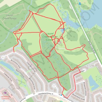
Name: Laurel Creek Nature Centre trail, distance, elevation, map, profile, GPS track
Coordinates: 43.47243 -80.59229 43.48090 -80.58295
Thank you for supporting this site ❤️
Make a donation
Make a donation
Gear up for your next adventure:
As an Amazon Associate, this site earns from qualifying purchases at no extra cost to you.