Make a donation
Gear up for your next adventure:
As an Amazon Associate, this site earns from qualifying purchases at no extra cost to you.
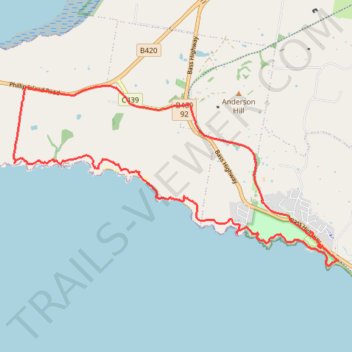
Kilcunda Coastal Reserve and George Bass Coastal Walk Loop
- Distance: 13.0 mi
- Elevation gain: 437 m
- Maximum elevation: 100 m
- Elevation loss: 420 m
- Minimum elevation: 0 m
- Moving time: 2 h 48 m
- Moving speed: 4.6 mph
- Maximum speed: 11.9 mph
- Total time: 3 h 14 m
- Global speed: 4.0 mph
Interactive trail map
Make a donation
Gear up for your next adventure:
As an Amazon Associate, this site earns from qualifying purchases at no extra cost to you.
Trail profile
- Distance: 13.0 mi
- Elevation gain: 437 m
- Maximum elevation: 100 m
- Elevation loss: 420 m
- Minimum elevation: 0 m
- Moving time: 2 h 48 m
- Moving speed: 4.6 mph
- Maximum speed: 11.9 mph
- Total time: 3 h 14 m
- Global speed: 4.0 mph
Make a donation
Gear up for your next adventure:
As an Amazon Associate, this site earns from qualifying purchases at no extra cost to you.
About this trail
Name: Kilcunda Coastal Reserve and George Bass Coastal Walk Loop trail, distance, elevation, map, profile, GPS track
Start: Bass Highway, Kilcunda, Bass Coast Shire, Victoria, 3995, Australia (-38.55244 145.47843)
Coordinates: -38.55576 145.40690 -38.52283 145.48277
Make a donation
Gear up for your next adventure:
As an Amazon Associate, this site earns from qualifying purchases at no extra cost to you.
Other hiking, mountain biking, running and outdoor activity trails
Click on a trail to view its statistics, map and profile.
Bass Coast Rail Trail
Australia > Victoria > Anderson
#Bike
Distance: 10.5 mi • Elevation gain: 83 m • Maximum elevation: 76 m