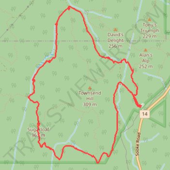
Trail, Sugar Loaf Mountain, Sooke Hills, Langford, BC
- Distance: 5.2 mi
- Elevation gain: 353 m
- Maximum elevation: 333 m
- Elevation loss: 355 m
- Minimum elevation: 143 m
- Moving time: 2 h 25 m
- Moving speed: 2.2 mph
- Maximum speed: 5.0 mph
- Total time: 3 h 31 m
- Global speed: 1.5 mph
Interactive trail map
Trail profile
- Distance: 5.2 mi
- Elevation gain: 353 m
- Maximum elevation: 333 m
- Elevation loss: 355 m
- Minimum elevation: 143 m
- Moving time: 2 h 25 m
- Moving speed: 2.2 mph
- Maximum speed: 5.0 mph
- Total time: 3 h 31 m
- Global speed: 1.5 mph
About this trail
Name: Trail, Sugar Loaf Mountain, Sooke Hills, Langford, BC trail, distance, elevation, map, profile, GPS track
Coordinates: 48.41027 -123.60532 48.42900 -123.58491
Other hiking, mountain biking, running and outdoor activity trails
Click on a trail to view its statistics, map and profile.