Import a GPX file

New gravel track built for power grid work in 2026 above Loch Long and Three Lochs Way

  • Distance: 1.9 mi
  • Elevation gain: 127 m
  • Maximum elevation: 311 m
  • Elevation loss: 158 m
  • Minimum elevation: 156 m

Interactive trail map

Trail profile

  • Distance: 1.9 mi
  • Elevation gain: 127 m
  • Maximum elevation: 311 m
  • Elevation loss: 158 m
  • Minimum elevation: 156 m

About this trail
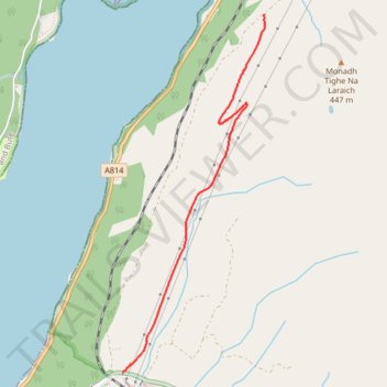
Name: New gravel track built for power grid work in 2026 above Loch Long and Three Lochs Way trail, distance, elevation, map, profile, GPS track

Start: A814, Ardgartan, Arrochar, Argyll and Bute, Scotland, United Kingdom (56.18431 -4.76464)

End: Glen Douglas Road, Invergroin, Argyll and Bute, Scotland, G83 7AZ, United Kingdom (56.16299 -4.77984)

Coordinates: 56.16299 -4.77984 56.18431 -4.76457

Topography: Argyll and Bute topographic map, elevation, terrain

Other hiking, mountain biking, running and outdoor activity trails

Click on a trail to view its statistics, map and profile.

Munro hillwalk Meall Dearg Sgorr nam Fiannaidh Aonach Eagach

United Kingdom > Scotland > Highland

#Munro #hillwalk #Meall #Dearg #Aonach #Eagach

Distance: 107.8 mi • Elevation gain: 2,915 m • Maximum elevation: 962 m

Gear up for your next adventure:

🗺️Scratch-off Peak Maps - Track your progress climbing Munros or Wainwrights
🧢Thermal Beanie Hats - Prevent heat loss from the head in windy summit conditions
🕶️Polarized Sunglasses - Reduces glare from snow and water when reading terrain
🪓Outdoor Multitools - Versatile tools for hiking and camping
🧦Hiking Socks - Breathable socks designed to prevent blisters on long walks

As an Amazon Associate, this site earns from qualifying purchases at no extra cost to you.