
Valley of 1000 Devils Loop Trail in Grasslands National Park
- Distance: 6.6 mi
- Elevation gain: 147 m
- Maximum elevation: 900 m
- Elevation loss: 149 m
- Minimum elevation: 840 m
- Moving time: 2 h 32 m
- Moving speed: 2.6 mph
- Maximum speed: 3.3 mph
- Total time: 2 h 59 m
- Global speed: 2.2 mph
Interactive trail map
Trail profile
- Distance: 6.6 mi
- Elevation gain: 147 m
- Maximum elevation: 900 m
- Elevation loss: 149 m
- Minimum elevation: 840 m
- Moving time: 2 h 32 m
- Moving speed: 2.6 mph
- Maximum speed: 3.3 mph
- Total time: 2 h 59 m
- Global speed: 2.2 mph
About this trail
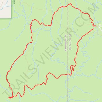
Name: Valley of 1000 Devils Loop Trail in Grasslands National Park trail, distance, elevation, map, profile, GPS track
Start: Rock Creek Trail, Old Post No. 43, Saskatchewan, Canada (49.07016 -106.53120)
End: Creek to Peak Trail, Old Post No. 43, Saskatchewan, Canada (49.07078 -106.53016)
Coordinates: 49.05236 -106.56527 49.07653 -106.53016
Other hiking, mountain biking, running and outdoor activity trails
Click on a trail to view its statistics, map and profile.

Red Butes and Old Wagon Trails
Canada > Saskatchewan > Old Post No. 43
Grasslands National Park
Distance: 10.3 mi • Elevation gain: 204 m • Maximum elevation: 917 m