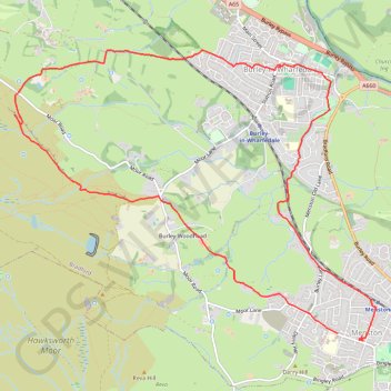
Burley Woodhead walk (foot)
Menston - Burley Woodhead - Burley - Menston
- Distance: 7.5 mi
- Elevation gain: 253 m
- Maximum elevation: 299 m
- Elevation loss: 258 m
- Minimum elevation: 71 m
- Moving time: 2 h 58 m
- Moving speed: 2.5 mph
- Maximum speed: 4.7 mph
- Total time: 4 h 9 m
- Global speed: 1.8 mph
Interactive trail map
Trail profile
- Distance: 7.5 mi
- Elevation gain: 253 m
- Maximum elevation: 299 m
- Elevation loss: 258 m
- Minimum elevation: 71 m
- Moving time: 2 h 58 m
- Moving speed: 2.5 mph
- Maximum speed: 4.7 mph
- Total time: 4 h 9 m
- Global speed: 1.8 mph
About this trail
Name: Burley Woodhead walk (foot) trail, distance, elevation, map, profile, GPS track
Coordinates: 53.88891 -1.78991 53.91465 -1.73560
Topography: Bradford topographic map, elevation, terrain
Other hiking, mountain biking, running and outdoor activity trails
Click on a trail to view its statistics, map and profile.
Otley - Draughton/Skipton Moor and return
United Kingdom > England > Leeds
Distance: 25.7 mi • Elevation gain: 456 m • Maximum elevation: 318 m