Import a GPX file

Kelly Pocket Loop

  • Distance: 6.3 mi
  • Elevation gain: 222 m
  • Maximum elevation: 2,084 m
  • Elevation loss: 222 m
  • Minimum elevation: 1,932 m

Interactive trail map

Trail profile

  • Distance: 6.3 mi
  • Elevation gain: 222 m
  • Maximum elevation: 2,084 m
  • Elevation loss: 222 m
  • Minimum elevation: 1,932 m

About this trail
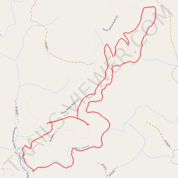
Name: Kelly Pocket Loop trail, distance, elevation, map, profile, GPS track

Start: Forest Service Road 237, Kachina Village, Coconino County, Arizona, United States (35.08085 -111.69697)

End: Forest Service Road 237, Kachina Village, Coconino County, Arizona, United States (35.08088 -111.69700)

Coordinates: 35.05869 -111.71885 35.08092 -111.69678

Gear up for your next adventure:

🧴Sport Sunscreen Sticks - High-protection sunblock that won't run into your eyes on the trail
🔦LED Camping Lanterns - Illumination for reading maps inside your tent at night
🛰️Handheld GPS Devices - Reliable GPS units for hiking and outdoor navigation
🥾Hiking Boot Waterproofing Wax - Maintain the lifespan of your leather trekking boots
🎒Multi-day Trekking Packs - Large capacity backpacks for wild camping and long-distance trails

As an Amazon Associate, this site earns from qualifying purchases at no extra cost to you.