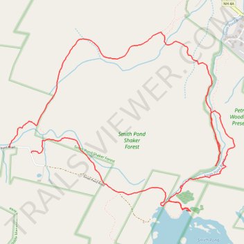
Smith Pond Shaker Forest Loop
- Distance: 5.6 mi
- Elevation gain: 330 m
- Maximum elevation: 522 m
- Elevation loss: 343 m
- Minimum elevation: 287 m
- Moving time: 3 h 14 m
- Moving speed: 1.7 mph
- Maximum speed: 8.7 mph
- Total time: 4 h 6 m
- Global speed: 1.4 mph
Interactive trail map
Trail profile
- Distance: 5.6 mi
- Elevation gain: 330 m
- Maximum elevation: 522 m
- Elevation loss: 343 m
- Minimum elevation: 287 m
- Moving time: 3 h 14 m
- Moving speed: 1.7 mph
- Maximum speed: 8.7 mph
- Total time: 4 h 6 m
- Global speed: 1.4 mph
About this trail
Name: Smith Pond Shaker Forest Loop trail, distance, elevation, map, profile, GPS track
Coordinates: 43.58975 -72.15915 43.60543 -72.13200
Other hiking, mountain biking, running and outdoor activity trails
Click on a trail to view its statistics, map and profile.
Crystal Lake Trail
United States > New Hampshire > Grafton County > Enfield
Distance: 13.9 mi • Elevation gain: 357 m • Maximum elevation: 345 m