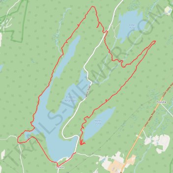
Clinton Reservoir Loop via Fire Tower Ridge Trail and Bearfort Waters-Clinton/Highlands Trail - Newark Watershed
- Distance: 11.6 mi
- Elevation gain: 347 m
- Maximum elevation: 408 m
- Elevation loss: 356 m
- Minimum elevation: 286 m
- Moving time: 6 h 42 m
- Moving speed: 1.7 mph
- Maximum speed: 5.7 mph
- Total time: 7 h 31 m
- Global speed: 1.5 mph
Interactive trail map
Trail profile
- Distance: 11.6 mi
- Elevation gain: 347 m
- Maximum elevation: 408 m
- Elevation loss: 356 m
- Minimum elevation: 286 m
- Moving time: 6 h 42 m
- Moving speed: 1.7 mph
- Maximum speed: 5.7 mph
- Total time: 7 h 31 m
- Global speed: 1.5 mph
About this trail
Name: Clinton Reservoir Loop via Fire Tower Ridge Trail and Bearfort Waters-Clinton/Highlands Trail - Newark Watershed trail, distance, elevation, map, profile, GPS track
Coordinates: 41.07161 -74.46506 41.11323 -74.41739
Other hiking, mountain biking, running and outdoor activity trails
Click on a trail to view its statistics, map and profile.
Hanks Pond Loop via Fire Tower West Trail and Hanks East Trail - Newark Watershed
United States > New Jersey > Passaic County > West Milford > Clinton
Description:
Distance: 7.9 mi • Elevation gain: 229 m • Maximum elevation: 408 m
Buckabear Pond Trail and Clinton West Trail loop
United States > New Jersey > Passaic County > West Milford
Distance: 2.8 mi • Elevation gain: 118 m • Maximum elevation: 366 m
Clinton Reservoir
United States > New Jersey > Passaic County > West Milford
Newark Watershed
Distance: 5.3 mi • Elevation gain: 177 m • Maximum elevation: 378 m
Hanks East Trail
United States > New Jersey > Passaic County > West Milford
Distance: 3.6 mi • Elevation gain: 91 m • Maximum elevation: 335 m