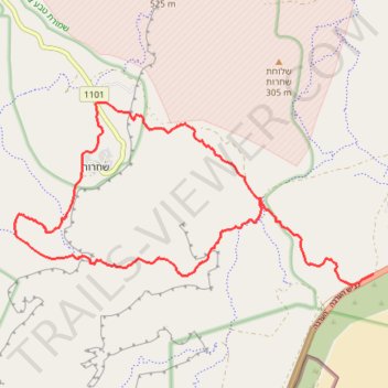
Yotveta - Shaharut
יטבתה לשחרות: מעלה זוגן וביקור בישוב הכי קול בערבה
- Distance: 13.6 mi
- Elevation gain: 770 m
- Maximum elevation: 597 m
- Elevation loss: 770 m
- Minimum elevation: 68 m
- Moving time: 6 h 37 m
- Moving speed: 2.1 mph
- Maximum speed: 2.5 mph
- Total time: 6 h 37 m
- Global speed: 2.1 mph
Interactive trail map
Trail profile
- Distance: 13.6 mi
- Elevation gain: 770 m
- Maximum elevation: 597 m
- Elevation loss: 770 m
- Minimum elevation: 68 m
- Moving time: 6 h 37 m
- Moving speed: 2.1 mph
- Maximum speed: 2.5 mph
- Total time: 6 h 37 m
- Global speed: 2.1 mph
About this trail
Name: Yotveta - Shaharut trail, distance, elevation, map, profile, GPS track
Coordinates: 29.88390 34.98368 29.91450 35.05304
Other hiking, mountain biking, running and outdoor activity trails
Click on a trail to view its statistics, map and profile.
Mount Yotveta and Mount Argaman
Israel > South District > Hevel Eilot Regional Council > Yotvata
הר יוטבתה והר ארגמן: מעלה צאלה וחיבור על שביל ישראל
Distance: 18.8 mi • Elevation gain: 937 m • Maximum elevation: 721 m
Marathon Timna Circle
Israel > South District > Hevel Eilot Regional Council > Yotvata
מרתון סובב תמנע: סובב מוניומנטי של בקעת תמנע מיוטבתה לבאר אורה
Distance: 26.4 mi • Elevation gain: 1,359 m • Maximum elevation: 837 m