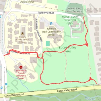
Walking paths in and around Lucas Valley Park in Lucas Valley
- Distance: 0.8 mi
- Elevation gain: 4 m
- Maximum elevation: 46 m
- Elevation loss: 13 m
- Minimum elevation: 34 m
- Moving time: 14 m 1 s
- Moving speed: 3.3 mph
- Maximum speed: 4.7 mph
- Total time: 14 m 1 s
- Global speed: 3.3 mph
Interactive trail map
Trail profile
- Distance: 0.8 mi
- Elevation gain: 4 m
- Maximum elevation: 46 m
- Elevation loss: 13 m
- Minimum elevation: 34 m
- Moving time: 14 m 1 s
- Moving speed: 3.3 mph
- Maximum speed: 4.7 mph
- Total time: 14 m 1 s
- Global speed: 3.3 mph
About this trail
Name: Walking paths in and around Lucas Valley Park in Lucas Valley trail, distance, elevation, map, profile, GPS track
Coordinates: 38.02565 -122.56875 38.02831 -122.56410
Other hiking, mountain biking, running and outdoor activity trails
Click on a trail to view its statistics, map and profile.
Point Reyes Loop
United States > California > Marin County > Mill Valley
Distance: 62.3 mi • Elevation gain: 1,900 m • Maximum elevation: 236 m