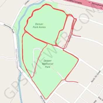
Denver park in Denver, Pennsylvania
- Distance: 3.5 mi
- Elevation gain: 35 m
- Maximum elevation: 129 m
- Elevation loss: 36 m
- Minimum elevation: 119 m
- Moving time: 35 m 28 s
- Moving speed: 6.0 mph
- Maximum speed: 16.3 mph
- Total time: 36 m 55 s
- Global speed: 5.7 mph
Interactive trail map
Trail profile
- Distance: 3.5 mi
- Elevation gain: 35 m
- Maximum elevation: 129 m
- Elevation loss: 36 m
- Minimum elevation: 119 m
- Moving time: 35 m 28 s
- Moving speed: 6.0 mph
- Maximum speed: 16.3 mph
- Total time: 36 m 55 s
- Global speed: 5.7 mph
About this trail
Name: Denver park in Denver, Pennsylvania trail, distance, elevation, map, profile, GPS track
End: 733, Pine Street, Denver, Lancaster County, Pennsylvania, 17517, United States (40.23699 -76.13985)
Coordinates: 40.23622 -76.14332 40.24072 -76.13969
Other hiking, mountain biking, running and outdoor activity trails
Click on a trail to view its statistics, map and profile.
Denver Park trail
United States > Pennsylvania > Lancaster County > Denver
Distance: 1.3 mi • Elevation gain: 12 m • Maximum elevation: 127 m
Denver Park Annex
United States > Pennsylvania > Lancaster County > Denver
Afternoon Loop Ride
Distance: 1.2 mi • Elevation gain: 13 m • Maximum elevation: 131 m