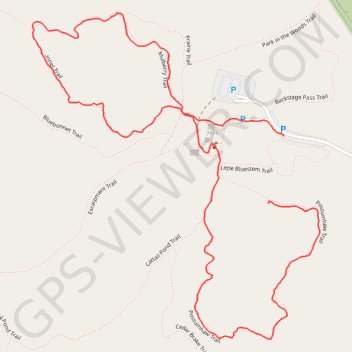
Cedar Ridge Preserve loop trails
- Distance: 1.4 mi
- Elevation gain: 40 m
- Maximum elevation: 232 m
- Elevation loss: 31 m
- Minimum elevation: 208 m
- Moving time: 30 m 15 s
- Moving speed: 2.9 mph
- Maximum speed: 4.7 mph
- Total time: 30 m 15 s
- Global speed: 2.9 mph
Interactive trail map
Trail profile
- Distance: 1.4 mi
- Elevation gain: 40 m
- Maximum elevation: 232 m
- Elevation loss: 31 m
- Minimum elevation: 208 m
- Moving time: 30 m 15 s
- Moving speed: 2.9 mph
- Maximum speed: 4.7 mph
- Total time: 30 m 15 s
- Global speed: 2.9 mph
About this trail
Name: Cedar Ridge Preserve loop trails trail, distance, elevation, map, profile, GPS track
Start: Possumhaw Trail, Dallas, Dallas County, Texas, 75249, United States (32.63678 -96.95763)
End: Little Bluestem Trail, Dallas, Dallas County, Texas, 75249, United States (32.63796 -96.95730)
Coordinates: 32.63442 -96.96251 32.64010 -96.95656