Thank you for supporting this site ❤️
Make a donation
Make a donation
Gear up for your next adventure:
As an Amazon Associate, this site earns from qualifying purchases at no extra cost to you.
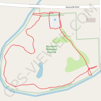
Trails and parking at Mooreville Riverbend Preserve in Mooreville, MI
- Distance: 0.7 mi
- Elevation gain: 5 m
- Maximum elevation: 220 m
- Elevation loss: 5 m
- Minimum elevation: 215 m
- Moving time: 11 m 11 s
- Moving speed: 3.6 mph
- Maximum speed: 6.4 mph
- Total time: 11 m 11 s
- Global speed: 3.6 mph
Interactive trail map
Thank you for supporting this site ❤️
Make a donation
Make a donation
Gear up for your next adventure:
As an Amazon Associate, this site earns from qualifying purchases at no extra cost to you.
Trail profile
- Distance: 0.7 mi
- Elevation gain: 5 m
- Maximum elevation: 220 m
- Elevation loss: 5 m
- Minimum elevation: 215 m
- Moving time: 11 m 11 s
- Moving speed: 3.6 mph
- Maximum speed: 6.4 mph
- Total time: 11 m 11 s
- Global speed: 3.6 mph
Thank you for supporting this site ❤️
Make a donation
Make a donation
Gear up for your next adventure:
As an Amazon Associate, this site earns from qualifying purchases at no extra cost to you.
About this trail
Name: Trails and parking at Mooreville Riverbend Preserve in Mooreville, MI trail, distance, elevation, map, profile, GPS track
Coordinates: 42.10099 -83.73680 42.10289 -83.73369
Thank you for supporting this site ❤️
Make a donation
Make a donation
Gear up for your next adventure:
As an Amazon Associate, this site earns from qualifying purchases at no extra cost to you.