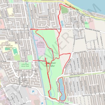
Little River Corridor
- Distance: 6.6 mi
- Elevation gain: 21 m
- Maximum elevation: 181 m
- Elevation loss: 21 m
- Minimum elevation: 175 m
- Moving time: 47 m 51 s
- Moving speed: 8.3 mph
- Maximum speed: 18.2 mph
- Total time: 49 m 59 s
- Global speed: 8.0 mph
Interactive trail map
Trail profile
- Distance: 6.6 mi
- Elevation gain: 21 m
- Maximum elevation: 181 m
- Elevation loss: 21 m
- Minimum elevation: 175 m
- Moving time: 47 m 51 s
- Moving speed: 8.3 mph
- Maximum speed: 18.2 mph
- Total time: 49 m 59 s
- Global speed: 8.0 mph
About this trail
Name: Little River Corridor trail, distance, elevation, map, profile, GPS track
Start: Ganatchio Trail, Windsor, Ontario, N8S 0A1, Canada (42.32644 -82.92513)
End: 8555, Little River Road, Windsor, Ontario, N8S 2B5, Canada (42.32732 -82.92887)
Coordinates: 42.31936 -82.92963 42.33845 -82.91766