Make a donation
Gear up for your next adventure:
As an Amazon Associate, this site earns from qualifying purchases at no extra cost to you.
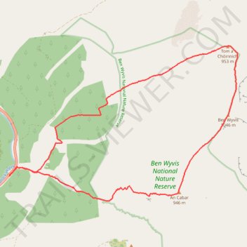
Munro Hillwalk - An Cabar, Ben Wyvis and Tom a' Chòinich Loop in Ben Wyvis National Nature Reserve
- Distance: 10.4 mi
- Elevation gain: 1,011 m
- Maximum elevation: 1,042 m
- Elevation loss: 1,010 m
- Minimum elevation: 147 m
- Moving time: 4 h 44 m
- Moving speed: 2.2 mph
- Maximum speed: 4.6 mph
- Total time: 5 h 6 m
- Global speed: 2.0 mph
Interactive trail map
Make a donation
Gear up for your next adventure:
As an Amazon Associate, this site earns from qualifying purchases at no extra cost to you.
Trail profile
- Distance: 10.4 mi
- Elevation gain: 1,011 m
- Maximum elevation: 1,042 m
- Elevation loss: 1,010 m
- Minimum elevation: 147 m
- Moving time: 4 h 44 m
- Moving speed: 2.2 mph
- Maximum speed: 4.6 mph
- Total time: 5 h 6 m
- Global speed: 2.0 mph
Make a donation
Gear up for your next adventure:
As an Amazon Associate, this site earns from qualifying purchases at no extra cost to you.
About this trail
Name: Munro Hillwalk - An Cabar, Ben Wyvis and Tom a' Chòinich Loop in Ben Wyvis National Nature Reserve trail, distance, elevation, map, profile, GPS track
Start: Ben Wyvis Path, Highland, Scotland, United Kingdom (57.66607 -4.66640)
End: Ben Wyvis Path, Highland, Scotland, United Kingdom (57.66593 -4.66651)
Coordinates: 57.66064 -4.66651 57.69377 -4.57543
Topography: Highland topographic map, elevation, terrain
Make a donation
Gear up for your next adventure:
As an Amazon Associate, this site earns from qualifying purchases at no extra cost to you.