Thank you for supporting this site ❤️
Make a donation
Make a donation
Gear up for your next adventure:
As an Amazon Associate, this site earns from qualifying purchases at no extra cost to you.
Goethe Forest and Watermelon Pond Loop
Interactive trail map
Thank you for supporting this site ❤️
Make a donation
Make a donation
Gear up for your next adventure:
As an Amazon Associate, this site earns from qualifying purchases at no extra cost to you.
Trail profile
- Distance: 6.3 mi
- Elevation gain: 12 m
- Maximum elevation: 24 m
- Elevation loss: 12 m
- Minimum elevation: 19 m
Thank you for supporting this site ❤️
Make a donation
Make a donation
Gear up for your next adventure:
As an Amazon Associate, this site earns from qualifying purchases at no extra cost to you.
About this trail
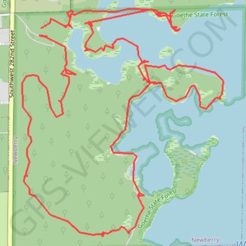
Name: Goethe Forest and Watermelon Pond Loop trail, distance, elevation, map, profile, GPS track
Start: Southwest 282nd Street, Newberry, Alachua County, Florida, United States (29.56476 -82.63755)
End: Southwest 282nd Street, Newberry, Alachua County, Florida, United States (29.56427 -82.63712)
Coordinates: 29.55193 -82.63885 29.56592 -82.62464
Thank you for supporting this site ❤️
Make a donation
Make a donation
Gear up for your next adventure:
As an Amazon Associate, this site earns from qualifying purchases at no extra cost to you.