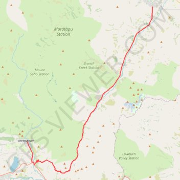
Import a GPX file

Arrowton - Wanaka

#Bike

  • Distance: 32.7 mi
  • Elevation gain: 861 m
  • Maximum elevation: 1,082 m
  • Elevation loss: 933 m
  • Minimum elevation: 337 m

Interactive trail map

Trail profile

  • Distance: 32.7 mi
  • Elevation gain: 861 m
  • Maximum elevation: 1,082 m
  • Elevation loss: 933 m
  • Minimum elevation: 337 m

About this trail

Other hiking, mountain biking, running and outdoor activity trails

Click on a trail to view its statistics, map and profile.

Tour Te Waipounamu

New Zealand > Tasman > Tasman District > Port Pūponga

Bikepacking race through the South Island of New Zealand. #Bike #Race #Island #Sea #Pacific #Ocean #Nature #Mountain #Forest #Countryside

Distance: 820.8 mi • Elevation gain: 23,362 m • Maximum elevation: 1,946 m

Gear up for your next adventure:

🧼Technical Clothing Wash - Special soap to clean and restore waterproof membranes
🔦Head Torches - Hands-free lighting for hiking and camping
🧭GPS Trackers - Tracking devices for safety and navigation
🧥Breathable Waterproof Jackets - Essential rain protection for the unpredictable British climate
🌂Windproof Trekking Umbrellas - Surprising but effective rain protection on low-wind trails

As an Amazon Associate, this site earns from qualifying purchases at no extra cost to you.