Thank you for supporting this site ❤️
Make a donation
Make a donation
Gear up for your next adventure:
As an Amazon Associate, this site earns from qualifying purchases at no extra cost to you.
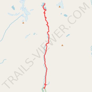
US. CA. Trinity Alps. Canyon Creek Lakes
- Distance: 9.1 mi
- Elevation gain: 949 m
- Maximum elevation: 1,759 m
- Elevation loss: 156 m
- Minimum elevation: 939 m
- Moving time: 5 h 15 m
- Moving speed: 1.7 mph
- Maximum speed: 6.9 mph
- Total time: 8 h 43 m
- Global speed: 1.0 mph
Interactive trail map
Thank you for supporting this site ❤️
Make a donation
Make a donation
Gear up for your next adventure:
As an Amazon Associate, this site earns from qualifying purchases at no extra cost to you.
Trail profile
- Distance: 9.1 mi
- Elevation gain: 949 m
- Maximum elevation: 1,759 m
- Elevation loss: 156 m
- Minimum elevation: 939 m
- Moving time: 5 h 15 m
- Moving speed: 1.7 mph
- Maximum speed: 6.9 mph
- Total time: 8 h 43 m
- Global speed: 1.0 mph
Thank you for supporting this site ❤️
Make a donation
Make a donation
Gear up for your next adventure:
As an Amazon Associate, this site earns from qualifying purchases at no extra cost to you.
About this trail
Name: US. CA. Trinity Alps. Canyon Creek Lakes trail, distance, elevation, map, profile, GPS track
End: Canyon Creek Trail, Trinity County, California, United States (40.97642 -123.02330)
Coordinates: 40.88719 -123.02597 40.97642 -123.01735
Thank you for supporting this site ❤️
Make a donation
Make a donation
Gear up for your next adventure:
As an Amazon Associate, this site earns from qualifying purchases at no extra cost to you.