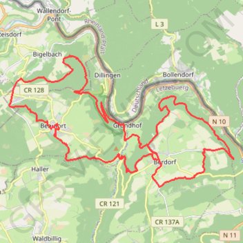
Berdorf-Beaufort
Berdorf-Beaufort
- Distance: 24.0 mi
- Elevation gain: 998 m
- Maximum elevation: 414 m
- Elevation loss: 998 m
- Minimum elevation: 177 m
Interactive trail map
Trail profile
- Distance: 24.0 mi
- Elevation gain: 998 m
- Maximum elevation: 414 m
- Elevation loss: 998 m
- Minimum elevation: 177 m
About this trail
Name: Berdorf-Beaufort trail, distance, elevation, map, profile, GPS track
Coordinates: 49.81330 6.26607 49.85948 6.38890
Other hiking, mountain biking, running and outdoor activity trails
Click on a trail to view its statistics, map and profile.
GR005_Parcours-principal_2021-05-06
Netherlands > Limburg > Maastricht
GR005_Parcours-principal_2021-05-06
Distance: 205.8 mi • Elevation gain: 8,983 m • Maximum elevation: 572 m
Riethoven naar Oostenrijk
Netherlands > North Brabant > Riethoven > Eind
Distance: 573.0 mi • Elevation gain: 13,629 m • Maximum elevation: 1,897 m
Eurovelo 15 - Strasbourg Rotterdam
France > Grand Est > Bas-Rhin > Strasbourg
Distance: 554.1 mi • Elevation gain: 2,104 m • Maximum elevation: 146 m