Thank you for supporting this site ❤️
Make a donation
Make a donation
Gear up for your next adventure:
As an Amazon Associate, this site earns from qualifying purchases at no extra cost to you.
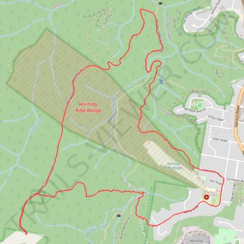
Berowra Valley Quarry Firetrail Loop
- Distance: 6.6 mi
- Elevation gain: 356 m
- Maximum elevation: 213 m
- Elevation loss: 357 m
- Minimum elevation: 50 m
- Moving time: 1 h 20 m
- Moving speed: 5.0 mph
- Maximum speed: 7.8 mph
- Total time: 1 h 21 m
- Global speed: 4.9 mph
Interactive trail map
Thank you for supporting this site ❤️
Make a donation
Make a donation
Gear up for your next adventure:
As an Amazon Associate, this site earns from qualifying purchases at no extra cost to you.
Trail profile
- Distance: 6.6 mi
- Elevation gain: 356 m
- Maximum elevation: 213 m
- Elevation loss: 357 m
- Minimum elevation: 50 m
- Moving time: 1 h 20 m
- Moving speed: 5.0 mph
- Maximum speed: 7.8 mph
- Total time: 1 h 21 m
- Global speed: 4.9 mph
Thank you for supporting this site ❤️
Make a donation
Make a donation
Gear up for your next adventure:
As an Amazon Associate, this site earns from qualifying purchases at no extra cost to you.
About this trail
Name: Berowra Valley Quarry Firetrail Loop trail, distance, elevation, map, profile, GPS track
Coordinates: -33.69639 151.06938 -33.67320 151.09461
Thank you for supporting this site ❤️
Make a donation
Make a donation
Gear up for your next adventure:
As an Amazon Associate, this site earns from qualifying purchases at no extra cost to you.
Other hiking, mountain biking, running and outdoor activity trails
Click on a trail to view its statistics, map and profile.