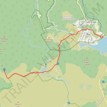
Tawonga Huts to Rocky Valley Storage via Pretty Valley Pondage in Australian Alps
- Distance: 7.3 mi
- Elevation gain: 313 m
- Maximum elevation: 1,809 m
- Elevation loss: 356 m
- Minimum elevation: 1,606 m
- Moving time: 2 h 41 m
- Moving speed: 2.7 mph
- Maximum speed: 3.5 mph
- Total time: 3 h 9 m
- Global speed: 2.3 mph
Interactive trail map
Trail profile
- Distance: 7.3 mi
- Elevation gain: 313 m
- Maximum elevation: 1,809 m
- Elevation loss: 356 m
- Minimum elevation: 1,606 m
- Moving time: 2 h 41 m
- Moving speed: 2.7 mph
- Maximum speed: 3.5 mph
- Total time: 3 h 9 m
- Global speed: 2.3 mph
About this trail
Name: Tawonga Huts to Rocky Valley Storage via Pretty Valley Pondage in Australian Alps trail, distance, elevation, map, profile, GPS track
Start: Fainter Firetrail, Falls Creek, Alpine Shire, Victoria, 3699, Australia (-36.89770 147.20287)
End: Bogong High Plains Road, Falls Creek, Alpine Shire, Victoria, Australia (-36.87427 147.29231)
Coordinates: -36.90425 147.20287 -36.86843 147.29231
Other hiking, mountain biking, running and outdoor activity trails
Click on a trail to view its statistics, map and profile.
Fainter Firetrail to Mount Fainter in Alpine National Park
Australia > Victoria > Falls Creek Alpine Resort > Falls Creek
Distance: 25.4 mi • Elevation gain: 957 m • Maximum elevation: 1,837 m
Cope Hut to Mount Jaithmatang and Tawanga Huts in Autralian Alps
Distance: 9.3 mi • Elevation gain: 395 m • Maximum elevation: 1,826 m
Mount Jaithmathang to Falls Creek
Falls, Jaithmathang, Bogong
Distance: 9.5 mi • Elevation gain: 519 m • Maximum elevation: 1,826 m
Rocky Valley Storage to Cope Hut in Austalian Alps
Distance: 10.0 mi • Elevation gain: 411 m • Maximum elevation: 1,777 m