Make a donation
Gear up for your next adventure:
As an Amazon Associate, this site earns from qualifying purchases at no extra cost to you.
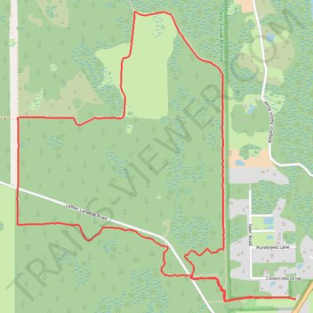
Deep Creek Extended Loop
- Distance: 5.5 mi
- Elevation gain: 8 m
- Maximum elevation: 15 m
- Elevation loss: 8 m
- Minimum elevation: 11 m
- Moving time: 1 h 54 m
- Moving speed: 2.9 mph
- Maximum speed: 4.1 mph
- Total time: 1 h 59 m
- Global speed: 2.8 mph
Interactive trail map
Make a donation
Gear up for your next adventure:
As an Amazon Associate, this site earns from qualifying purchases at no extra cost to you.
Trail profile
- Distance: 5.5 mi
- Elevation gain: 8 m
- Maximum elevation: 15 m
- Elevation loss: 8 m
- Minimum elevation: 11 m
- Moving time: 1 h 54 m
- Moving speed: 2.9 mph
- Maximum speed: 4.1 mph
- Total time: 1 h 59 m
- Global speed: 2.8 mph
Make a donation
Gear up for your next adventure:
As an Amazon Associate, this site earns from qualifying purchases at no extra cost to you.
About this trail
Name: Deep Creek Extended Loop trail, distance, elevation, map, profile, GPS track
Start: Yellow Trail, Volusia County, Florida, United States (28.95142 -81.09749)
End: Yellow Trail, Volusia County, Florida, United States (28.95144 -81.09733)
Coordinates: 28.95129 -81.11888 28.97090 -81.09733
Make a donation
Gear up for your next adventure:
As an Amazon Associate, this site earns from qualifying purchases at no extra cost to you.
Other hiking, mountain biking, running and outdoor activity trails
Click on a trail to view its statistics, map and profile.
Deep Creek Preserve - White Trail
United States > Florida > Volusia County > Alamana
Distance: 12.9 mi • Elevation gain: 36 m • Maximum elevation: 17 m