Make a donation
Gear up for your next adventure:
As an Amazon Associate, this site earns from qualifying purchases at no extra cost to you.
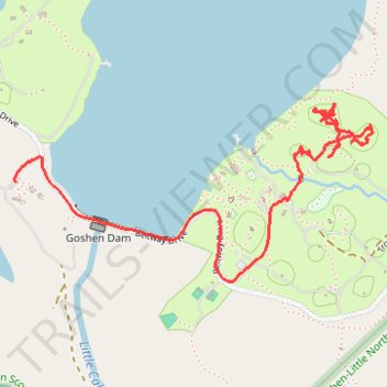
Tracked with OSMTracker for Android™
Marriott south
- Distance: 2.0 mi
- Elevation gain: 38 m
- Maximum elevation: 453 m
- Elevation loss: 54 m
- Minimum elevation: 414 m
- Moving time: 40 m 59 s
- Moving speed: 2.9 mph
- Maximum speed: 22.9 mph
- Total time: 58 m 35 s
- Global speed: 2.0 mph
Interactive trail map
Make a donation
Gear up for your next adventure:
As an Amazon Associate, this site earns from qualifying purchases at no extra cost to you.
Trail profile
- Distance: 2.0 mi
- Elevation gain: 38 m
- Maximum elevation: 453 m
- Elevation loss: 54 m
- Minimum elevation: 414 m
- Moving time: 40 m 59 s
- Moving speed: 2.9 mph
- Maximum speed: 22.9 mph
- Total time: 58 m 35 s
- Global speed: 2.0 mph
Make a donation
Gear up for your next adventure:
As an Amazon Associate, this site earns from qualifying purchases at no extra cost to you.
About this trail
Name: Tracked with OSMTracker for Android™ trail, distance, elevation, map, profile, GPS track
Start: Rivera Road, Rockbridge County, Virginia, 24439, United States (37.96169 -79.45006)
End: Camp Post Lane, Rockbridge County, Virginia, 24439, United States (37.96092 -79.46261)
Coordinates: 37.95774 -79.46266 37.96336 -79.44828
Make a donation
Gear up for your next adventure:
As an Amazon Associate, this site earns from qualifying purchases at no extra cost to you.
Other hiking, mountain biking, running and outdoor activity trails
Click on a trail to view its statistics, map and profile.
Goshen Pass Hiking via Jump Rock and Viewing Rock
United States > Virginia > Rockbridge County
Distance: 8.2 mi • Elevation gain: 728 m • Maximum elevation: 930 m
Tracked with OSMTracker for Android™
United States > Virginia > Rockbridge County
Marriott north
Distance: 8.1 mi • Elevation gain: 246 m • Maximum elevation: 490 m