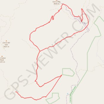
1 DuranSardinas 21mi
- Distance: 20.4 mi
- Elevation gain: 1,077 m
- Maximum elevation: 3,469 m
- Elevation loss: 1,003 m
- Minimum elevation: 2,677 m
Interactive trail map
Trail profile
- Distance: 20.4 mi
- Elevation gain: 1,077 m
- Maximum elevation: 3,469 m
- Elevation loss: 1,003 m
- Minimum elevation: 2,677 m
About this trail
Name: 1 DuranSardinas 21mi trail, distance, elevation, map, profile, GPS track
Start: Forest 76 Road, Taos County, New Mexico, United States (36.13393 -105.47871)
End: Forest 76 Road, Taos County, New Mexico, United States (36.14802 -105.45612)
Coordinates: 36.12712 -105.47871 36.20746 -105.40324