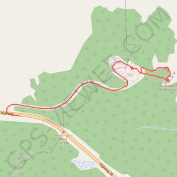
Washington Pass Overview
- Distance: 1.0 mi
- Elevation gain: 70 m
- Maximum elevation: 1,702 m
- Elevation loss: 92 m
- Minimum elevation: 1,650 m
- Moving time: 10 m 29 s
- Moving speed: 5.6 mph
- Maximum speed: 33.1 mph
- Total time: 13 m 11 s
- Global speed: 4.4 mph
Interactive trail map
Trail profile
- Distance: 1.0 mi
- Elevation gain: 70 m
- Maximum elevation: 1,702 m
- Elevation loss: 92 m
- Minimum elevation: 1,650 m
- Moving time: 10 m 29 s
- Moving speed: 5.6 mph
- Maximum speed: 33.1 mph
- Total time: 13 m 11 s
- Global speed: 4.4 mph
About this trail
Name: Washington Pass Overview trail, distance, elevation, map, profile, GPS track
End: North Cascades Highway, Chelan County, Washington, United States (48.52428 -120.65722)
Coordinates: 48.52428 -120.65808 48.52672 -120.64702