Thank you for supporting this site ❤️
Make a donation
Make a donation
Gear up for your next adventure:
As an Amazon Associate, this site earns from qualifying purchases at no extra cost to you.
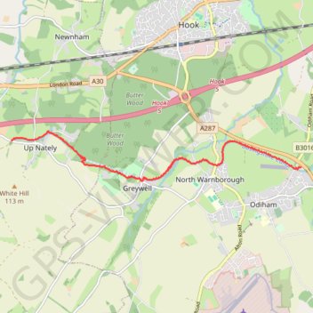
Basingstoke Canal from Up Nately to Odiham; near Hook, England
- Distance: 4.8 mi
- Elevation gain: 54 m
- Maximum elevation: 112 m
- Elevation loss: 56 m
- Minimum elevation: 75 m
- Moving time: 2 h 15 m
- Moving speed: 2.1 mph
- Maximum speed: 6.1 mph
- Total time: 3 h 39 m
- Global speed: 1.3 mph
Interactive trail map
Thank you for supporting this site ❤️
Make a donation
Make a donation
Gear up for your next adventure:
As an Amazon Associate, this site earns from qualifying purchases at no extra cost to you.
Trail profile
- Distance: 4.8 mi
- Elevation gain: 54 m
- Maximum elevation: 112 m
- Elevation loss: 56 m
- Minimum elevation: 75 m
- Moving time: 2 h 15 m
- Moving speed: 2.1 mph
- Maximum speed: 6.1 mph
- Total time: 3 h 39 m
- Global speed: 1.3 mph
Thank you for supporting this site ❤️
Make a donation
Make a donation
Gear up for your next adventure:
As an Amazon Associate, this site earns from qualifying purchases at no extra cost to you.
About this trail
Name: Basingstoke Canal from Up Nately to Odiham; near Hook, England trail, distance, elevation, map, profile, GPS track
Coordinates: 51.25722 -1.00583 51.26540 -0.92962
Topography: Basingstoke and Deane topographic map, elevation, terrain
Thank you for supporting this site ❤️
Make a donation
Make a donation
Gear up for your next adventure:
As an Amazon Associate, this site earns from qualifying purchases at no extra cost to you.