Thank you for supporting this site ❤️
Make a donation
Make a donation
Gear up for your next adventure:
As an Amazon Associate, this site earns from qualifying purchases at no extra cost to you.
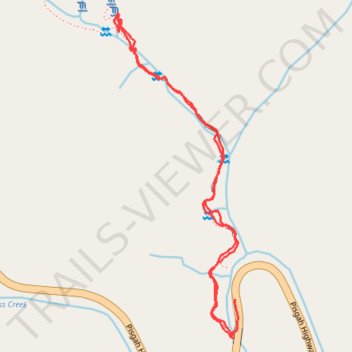
Moore Cove Falls hike
- Distance: 1.5 mi
- Elevation gain: 99 m
- Maximum elevation: 820 m
- Elevation loss: 103 m
- Minimum elevation: 756 m
- Moving time: 25 m 41 s
- Moving speed: 3.4 mph
- Maximum speed: 9.7 mph
- Total time: 45 m 23 s
- Global speed: 1.9 mph
Interactive trail map
Thank you for supporting this site ❤️
Make a donation
Make a donation
Gear up for your next adventure:
As an Amazon Associate, this site earns from qualifying purchases at no extra cost to you.
Trail profile
- Distance: 1.5 mi
- Elevation gain: 99 m
- Maximum elevation: 820 m
- Elevation loss: 103 m
- Minimum elevation: 756 m
- Moving time: 25 m 41 s
- Moving speed: 3.4 mph
- Maximum speed: 9.7 mph
- Total time: 45 m 23 s
- Global speed: 1.9 mph
Thank you for supporting this site ❤️
Make a donation
Make a donation
Gear up for your next adventure:
As an Amazon Associate, this site earns from qualifying purchases at no extra cost to you.
About this trail
Name: Moore Cove Falls hike trail, distance, elevation, map, profile, GPS track
Start: US 276, Transylvania County, North Carolina, United States (35.30483 -82.77448)
Coordinates: 35.30469 -82.77774 35.31186 -82.77439
Thank you for supporting this site ❤️
Make a donation
Make a donation
Gear up for your next adventure:
As an Amazon Associate, this site earns from qualifying purchases at no extra cost to you.