Thank you for supporting this site ❤️
Make a donation
Make a donation
Gear up for your next adventure:
As an Amazon Associate, this site earns from qualifying purchases at no extra cost to you.
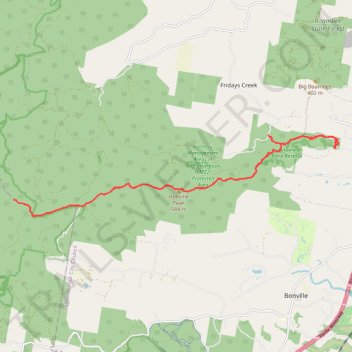
Peak Trail and Legge Lookout
- Distance: 20.7 mi
- Elevation gain: 1,790 m
- Maximum elevation: 829 m
- Elevation loss: 1,793 m
- Minimum elevation: 33 m
- Moving time: 4 h 38 m
- Moving speed: 4.5 mph
- Maximum speed: 9.3 mph
- Total time: 5 h 4 m
- Global speed: 4.1 mph
Interactive trail map
Thank you for supporting this site ❤️
Make a donation
Make a donation
Gear up for your next adventure:
As an Amazon Associate, this site earns from qualifying purchases at no extra cost to you.
Trail profile
- Distance: 20.7 mi
- Elevation gain: 1,790 m
- Maximum elevation: 829 m
- Elevation loss: 1,793 m
- Minimum elevation: 33 m
- Moving time: 4 h 38 m
- Moving speed: 4.5 mph
- Maximum speed: 9.3 mph
- Total time: 5 h 4 m
- Global speed: 4.1 mph
Thank you for supporting this site ❤️
Make a donation
Make a donation
Gear up for your next adventure:
As an Amazon Associate, this site earns from qualifying purchases at no extra cost to you.
About this trail
Name: Peak Trail and Legge Lookout trail, distance, elevation, map, profile, GPS track
Coordinates: -30.35167 152.94521 -30.32897 153.05015
Thank you for supporting this site ❤️
Make a donation
Make a donation
Gear up for your next adventure:
As an Amazon Associate, this site earns from qualifying purchases at no extra cost to you.