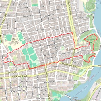
Providence - Blackstone Park
- Distance: 3.5 mi
- Elevation gain: 57 m
- Maximum elevation: 45 m
- Elevation loss: 55 m
- Minimum elevation: -6 m
- Moving time: 1 h 6 m
- Moving speed: 3.2 mph
- Maximum speed: 6.6 mph
- Total time: 1 h 15 m
- Global speed: 2.8 mph
Interactive trail map
Trail profile
- Distance: 3.5 mi
- Elevation gain: 57 m
- Maximum elevation: 45 m
- Elevation loss: 55 m
- Minimum elevation: -6 m
- Moving time: 1 h 6 m
- Moving speed: 3.2 mph
- Maximum speed: 6.6 mph
- Total time: 1 h 15 m
- Global speed: 2.8 mph
About this trail
Name: Providence - Blackstone Park trail, distance, elevation, map, profile, GPS track
Coordinates: 41.82888 -71.40076 41.83526 -71.37881
Other hiking, mountain biking, running and outdoor activity trails
Click on a trail to view its statistics, map and profile.
Cambridge - Providence Express
United States > Massachusetts > Middlesex County > Cambridge
Alewife -> Providence
Distance: 63.2 mi • Elevation gain: 961 m • Maximum elevation: 107 m
Dedham-Providence-Dedham
United States > Massachusetts > Norfolk County > Dedham
Distance: 126.0 mi • Elevation gain: 1,811 m • Maximum elevation: 167 m