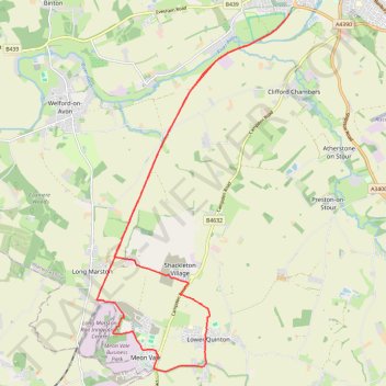
Stratford Greenway + Loop
- Distance: 13.5 mi
- Elevation gain: 73 m
- Maximum elevation: 65 m
- Elevation loss: 73 m
- Minimum elevation: 35 m
- Moving time: 1 h 45 m
- Moving speed: 7.7 mph
- Maximum speed: 9.8 mph
- Total time: 1 h 45 m
- Global speed: 7.7 mph
Interactive trail map
Trail profile
- Distance: 13.5 mi
- Elevation gain: 73 m
- Maximum elevation: 65 m
- Elevation loss: 73 m
- Minimum elevation: 35 m
- Moving time: 1 h 45 m
- Moving speed: 7.7 mph
- Maximum speed: 9.8 mph
- Total time: 1 h 45 m
- Global speed: 7.7 mph
About this trail
Name: Stratford Greenway + Loop trail, distance, elevation, map, profile, GPS track
Coordinates: 52.11568 -1.77498 52.18289 -1.71587
Topography: Stratford-on-Avon topographic map, elevation, terrain
Other hiking, mountain biking, running and outdoor activity trails
Click on a trail to view its statistics, map and profile.