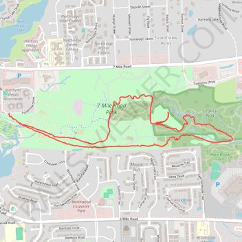
7 Mile Road Park loop trail
- Distance: 3.7 mi
- Elevation gain: 63 m
- Maximum elevation: 272 m
- Elevation loss: 63 m
- Minimum elevation: 234 m
- Moving time: 36 m 34 s
- Moving speed: 6.1 mph
- Maximum speed: 9.4 mph
- Total time: 41 m 14 s
- Global speed: 5.4 mph
Interactive trail map
Trail profile
- Distance: 3.7 mi
- Elevation gain: 63 m
- Maximum elevation: 272 m
- Elevation loss: 63 m
- Minimum elevation: 234 m
- Moving time: 36 m 34 s
- Moving speed: 6.1 mph
- Maximum speed: 9.4 mph
- Total time: 41 m 14 s
- Global speed: 5.4 mph
About this trail
Name: 7 Mile Road Park loop trail trail, distance, elevation, map, profile, GPS track
Coordinates: 42.41709 -83.46454 42.42155 -83.43894