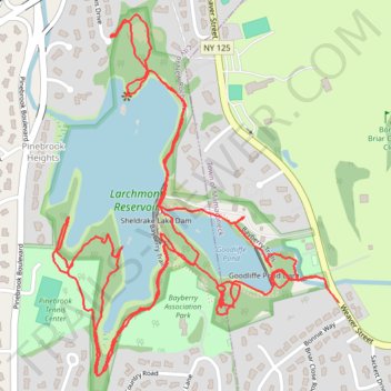
Larchmont Reservoir Trails
- Distance: 3.5 mi
- Elevation gain: 55 m
- Maximum elevation: 56 m
- Elevation loss: 54 m
- Minimum elevation: 28 m
- Moving time: 1 h 24 m
- Moving speed: 2.5 mph
- Maximum speed: 4.9 mph
- Total time: 1 h 38 m
- Global speed: 2.1 mph
Interactive trail map
Trail profile
- Distance: 3.5 mi
- Elevation gain: 55 m
- Maximum elevation: 56 m
- Elevation loss: 54 m
- Minimum elevation: 28 m
- Moving time: 1 h 24 m
- Moving speed: 2.5 mph
- Maximum speed: 4.9 mph
- Total time: 1 h 38 m
- Global speed: 2.1 mph
About this trail
Name: Larchmont Reservoir Trails trail, distance, elevation, map, profile, GPS track
Coordinates: 40.94824 -73.77654 40.95615 -73.76823
Other hiking, mountain biking, running and outdoor activity trails
Click on a trail to view its statistics, map and profile.
Leatherstocking Trail
United States > New York > Westchester County > Town of Mamaroneck
Distance: 7.9 mi • Elevation gain: 123 m • Maximum elevation: 48 m