Thank you for supporting this site ❤️
Make a donation
Make a donation
Gear up for your next adventure:
As an Amazon Associate, this site earns from qualifying purchases at no extra cost to you.
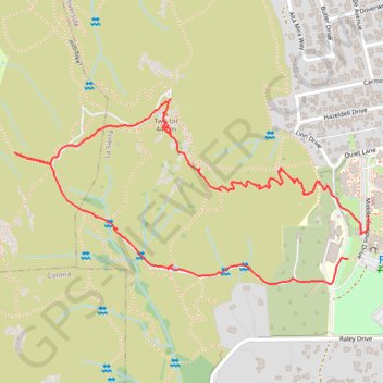
Two-bit Loop
- Distance: 1.9 mi
- Elevation gain: 180 m
- Maximum elevation: 432 m
- Elevation loss: 187 m
- Minimum elevation: 255 m
- Moving time: 55 m 8 s
- Moving speed: 2.1 mph
- Maximum speed: 10.8 mph
- Total time: 1 h 11 m
- Global speed: 1.6 mph
Interactive trail map
Thank you for supporting this site ❤️
Make a donation
Make a donation
Gear up for your next adventure:
As an Amazon Associate, this site earns from qualifying purchases at no extra cost to you.
Trail profile
- Distance: 1.9 mi
- Elevation gain: 180 m
- Maximum elevation: 432 m
- Elevation loss: 187 m
- Minimum elevation: 255 m
- Moving time: 55 m 8 s
- Moving speed: 2.1 mph
- Maximum speed: 10.8 mph
- Total time: 1 h 11 m
- Global speed: 1.6 mph
Thank you for supporting this site ❤️
Make a donation
Make a donation
Gear up for your next adventure:
As an Amazon Associate, this site earns from qualifying purchases at no extra cost to you.
About this trail
Name: Two-bit Loop trail, distance, elevation, map, profile, GPS track
Coordinates: 33.90938 -117.51417 33.91412 -117.50326
Thank you for supporting this site ❤️
Make a donation
Make a donation
Gear up for your next adventure:
As an Amazon Associate, this site earns from qualifying purchases at no extra cost to you.