Make a donation
Gear up for your next adventure:
As an Amazon Associate, this site earns from qualifying purchases at no extra cost to you.
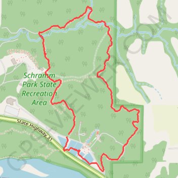
Schramm Park State Recreation Area Loop via Meditation Trail, Suspension Bridge Trail, Backwoods Trail, NorthLoop Trail and South Loop Trail
This loop hike through Schramm Park State Recreation Area offers a delightful blend of natural beauty and recreational opportunities. Along the way, hikers can enjoy lush greenery, scenic views of the Platte River, and the unique experience of crossing a suspension bridge. Additionally, the area features historical elements such as the old fish hatchery and geological displays, making it an engaging outing for nature lovers and families alike. #Hiking #Loop #Forest #River #Nature
- Distance: 2.5 mi
- Elevation gain: 73 m
- Maximum elevation: 365 m
- Elevation loss: 77 m
- Minimum elevation: 317 m
- Moving time: 43 m 18 s
- Moving speed: 3.4 mph
- Maximum speed: 9.6 mph
- Total time: 43 m 18 s
- Global speed: 3.4 mph
Interactive trail map
Make a donation
Gear up for your next adventure:
As an Amazon Associate, this site earns from qualifying purchases at no extra cost to you.
Trail profile
- Distance: 2.5 mi
- Elevation gain: 73 m
- Maximum elevation: 365 m
- Elevation loss: 77 m
- Minimum elevation: 317 m
- Moving time: 43 m 18 s
- Moving speed: 3.4 mph
- Maximum speed: 9.6 mph
- Total time: 43 m 18 s
- Global speed: 3.4 mph
Make a donation
Gear up for your next adventure:
As an Amazon Associate, this site earns from qualifying purchases at no extra cost to you.
About this trail
Name: Schramm Park State Recreation Area Loop via Meditation Trail, Suspension Bridge Trail, Backwoods Trail, NorthLoop Trail and South Loop Trail trail, distance, elevation, map, profile, GPS track
Start: Meditation Trail, Sarpy County, Nebraska, 68058, United States (41.02136 -96.24892)
End: Bike Fixation, Meditation Trail, Sarpy County, Nebraska, 68058, United States (41.02118 -96.24911)
Coordinates: 41.01897 -96.25146 41.02955 -96.24298
Make a donation
Gear up for your next adventure:
As an Amazon Associate, this site earns from qualifying purchases at no extra cost to you.
Other hiking, mountain biking, running and outdoor activity trails
Click on a trail to view its statistics, map and profile.
Afternoon hike at Schramm Park Nature Loop
United States > Nebraska > Sarpy County > Meadow
Distance: 2.4 mi • Elevation gain: 76 m • Maximum elevation: 365 m