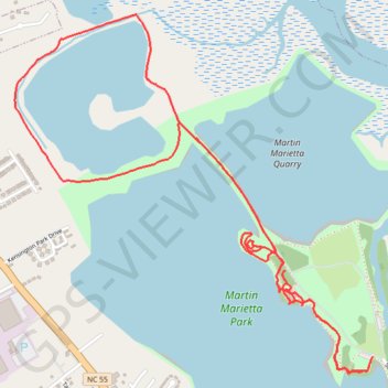
Explorer Trail, Dragonfly Trail, and Island Pond Loop in Martin Marietta Park
- Distance: 5.0 mi
- Elevation gain: 50 m
- Maximum elevation: 6 m
- Elevation loss: 50 m
- Minimum elevation: -5 m
- Moving time: 1 h 35 m
- Moving speed: 3.2 mph
- Maximum speed: 6.5 mph
- Total time: 1 h 36 m
- Global speed: 3.2 mph
Interactive trail map
Trail profile
- Distance: 5.0 mi
- Elevation gain: 50 m
- Maximum elevation: 6 m
- Elevation loss: 50 m
- Minimum elevation: -5 m
- Moving time: 1 h 35 m
- Moving speed: 3.2 mph
- Maximum speed: 6.5 mph
- Total time: 1 h 36 m
- Global speed: 3.2 mph
About this trail
Name: Explorer Trail, Dragonfly Trail, and Island Pond Loop in Martin Marietta Park trail, distance, elevation, map, profile, GPS track
Start: Explorer Trail, New Bern, Craven County, North Carolina, 28562, United States (35.13611 -77.08059)
End: Explorer Trail, New Bern, Craven County, North Carolina, 28562, United States (35.13590 -77.08072)
Coordinates: 35.13532 -77.10126 35.15226 -77.08059