Haystack Mountain Trail in Green Mountain National Forest
The Haystack Mountain Trail offers a moderately challenging route that leads hikers through a mix of hardwood and evergreen forests before reaching a scenic summit. From the top, the panoramic views extend over Deerfield Valley, Haystack Pond, Harriman Reservoir, and distant peaks like Mount Monadnock and Mount Snow, creating a rich tapestry of natural beauty. The trail’s varied terrain, including rocky sections and ridges, makes it a rewarding journey for those seeking peaceful vistas and the charm of Vermont’s highland landscapes. #Hiking #Mountain #Overlook #Forest #Nature
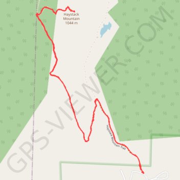
- Distance: 4.2 mi
- Elevation gain: 295 m
- Maximum elevation: 1,028 m
- Elevation loss: 295 m
- Minimum elevation: 740 m
- Moving time: 2 h 9 m
- Moving speed: 1.9 mph
- Maximum speed: 4.8 mph
- Total time: 2 h 32 m
- Global speed: 1.7 mph
Interactive trail map
Trail profile
- Distance: 4.2 mi
- Elevation gain: 295 m
- Maximum elevation: 1,028 m
- Elevation loss: 295 m
- Minimum elevation: 740 m
- Moving time: 2 h 9 m
- Moving speed: 1.9 mph
- Maximum speed: 4.8 mph
- Total time: 2 h 32 m
- Global speed: 1.7 mph
About this trail
Name: Haystack Mountain Trail in Green Mountain National Forest trail, distance, elevation, map, profile, GPS track
Start: 181, Upper Dam Road, Wilmington, Windham County, Vermont, 05363, United States (42.89975 -72.91094)
Coordinates: 42.89963 -72.92342 42.91409 -72.91067