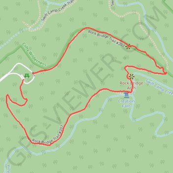
Rock Bridge Loop Trail in Red River Gorge Geological Area
The Rock Bridge Trail offers a pleasant and relatively short hike through striking natural features. Along the way, hikers are treated to views of the Rock Bridge, a rare sandstone arch that spans over a flowing stream, and the scenic Creation Falls, which cascades into a small, clear pool. The trail winds through lush forested areas, with rocky sections and steps carved into the terrain, providing both moderate challenges and rewarding vistas. #Hiking #Loop #Arch #Rock #Waterfall #Forest #Nature
- Distance: 1.4 mi
- Elevation gain: 74 m
- Maximum elevation: 350 m
- Elevation loss: 71 m
- Minimum elevation: 293 m
- Moving time: 37 m 2 s
- Moving speed: 2.3 mph
- Maximum speed: 4.4 mph
- Total time: 48 m 22 s
- Global speed: 1.8 mph
Interactive trail map
Trail profile
- Distance: 1.4 mi
- Elevation gain: 74 m
- Maximum elevation: 350 m
- Elevation loss: 71 m
- Minimum elevation: 293 m
- Moving time: 37 m 2 s
- Moving speed: 2.3 mph
- Maximum speed: 4.4 mph
- Total time: 48 m 22 s
- Global speed: 1.8 mph
About this trail
Name: Rock Bridge Loop Trail in Red River Gorge Geological Area trail, distance, elevation, map, profile, GPS track
Start: Rock Bridge Road, Wolfe County, Kentucky, 41302, United States (37.76999 -83.56679)
End: Rock Bridge Road, Wolfe County, Kentucky, 41302, United States (37.77024 -83.56632)
Coordinates: 37.76733 -83.56766 37.77209 -83.55946