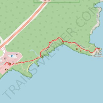
Shovel Point Trail
- Distance: 0.7 mi
- Elevation gain: 36 m
- Maximum elevation: 214 m
- Elevation loss: 58 m
- Minimum elevation: 181 m
- Moving time: 21 m 2 s
- Moving speed: 2.1 mph
- Maximum speed: 4.8 mph
- Total time: 30 m 31 s
- Global speed: 1.4 mph
Interactive trail map
Trail profile
- Distance: 0.7 mi
- Elevation gain: 36 m
- Maximum elevation: 214 m
- Elevation loss: 58 m
- Minimum elevation: 181 m
- Moving time: 21 m 2 s
- Moving speed: 2.1 mph
- Maximum speed: 4.8 mph
- Total time: 30 m 31 s
- Global speed: 1.4 mph
About this trail
Name: Shovel Point Trail trail, distance, elevation, map, profile, GPS track
End: Shovel Point Trail, Beaver Bay Township, Lake County, Minnesota, United States (47.33973 -91.18470)
Coordinates: 47.33838 -91.19603 47.34061 -91.18470